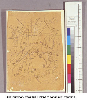
Battle of Gettysburg – July 2013 – 150th Anniversary
This manuscript map shows positions held during the Battle of Gettysburg in July 1863. Because of its small size, the map would have fit easily into a pocket for quick reference (Map A-7-19 RG 200 Paine Collection Maps). It was previously laminated to cream colored folder stock with cellulose acetate. All media underwent solubility tests, after which the map was delaminated and tears mended. It was lined with Japanese paper and wheat starch paper, and encapsulated in polyester film.
The map comes from the Paine Collection of Civil War Maps. The maps, ca. 300 in all, were given to the National Archives by Colonel W. H. Paine’s daughter at an unknown date. Col. Paine served under all the Generals of the Army of the Potomac, but mostly under General Meade. He was an engineer in the Army, and his maps were noted for their accuracy. Many were constructed from observations taken in captive balloons or while under enemy fire. Most if not all of the maps in the collection are by Col. Paine.